On Thursday, March 11, 1993, as my spring break was nearing an end, a large cluster of intense thunderstorms began to organize across the western Gulf of Mexico along a boundary between warm and cool air that had stalled over the region.
MORE: Dramatic images from Superstorm Sandy
The cluster of storms grew in coverage an intensity through that night, developing into an intense area of low-pressure by the following morning. By that Friday evening, the jet stream lined up over the growing cluster of storms to force an incredible intensification of the system, becoming a “Superstorm.”
While it was not a tropical system, the massive storm looked like one on satellite imagery as it approached Florida, making “landfall” late that Friday night.
As the storm moved across Florida, a line of severe thunderstorms developed, producing severe straight-line winds and nearly a dozen tornadoes.
A storm surge of nearly 12 feet battered the west coast of Florida, and the U.S. Coast Guard had to rescue more than 100 people from boats and ships in distress from the pounding waves. The line of storms raced across Florida, arriving in Cuba a few hours later where wind gusts of over 120 mph were reported by the Cuban Weather Service.
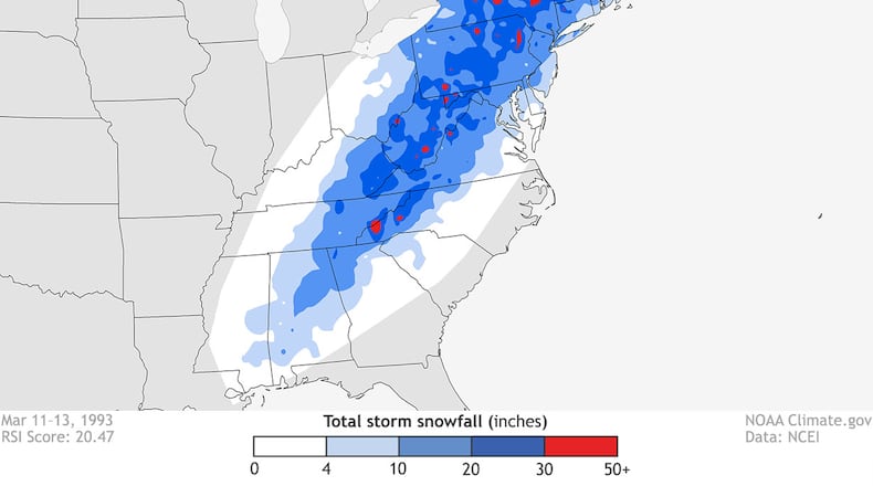
On the northwestern side of the storm, blizzard conditions developed from Alabama, Tennessee, the Carolinas and into the Ohio Valley and New England. By early in the afternoon on March 13, the barometric pressure of the storm system dropped lower than any storm system, tropical or non-tropical, ever recorded in the southeastern United States as it crossed the Carolinas. This generated snow that was blasted across a large region of the eastern United States with 40 to 60 mph wind gusts.
The storm moved out to sea on March 14, leaving behind a trail of devastating wind and tornado damage across Florida and southern Georgia. Mountains in Tennessee and North Carolina reported more than 50 inches of snow with lower elevations receiving up to 2 feet. Needless to say, I did not make it back to school that following Monday as my hometown of McMinnville received 15 inches of snow, closing roads for days.
MORE: The latest Storm Center 7 forecast
In Ohio, the Superstorm of 1993 dropped nearly 2 feet of snow across the southeastern third of the state with 6 to 10 inches of snow reported around Columbus. The storm did not impact the Miami Valley as hard as the rest of the state.
If you are curious how the 1993 Superstorm compared to the 1978 storm that many in Ohio remember, you probably wouldn’t be surprised to learn that the Blizzard of 1978 was more intense. However, the Blizzard of 78 was not nearly the same size and scope as the 1993 Superstorm.
The Blizzard of 1978 produced wind gusts of more than 70 mph, and it did produce the lowest barometric pressure ever recorded in Ohio, lower than the 1993 storm. The blizzard was responsible for more than 70 fatalities across the region.
However, the 1993 Superstorm affected around 40 percent of the population of United States and was responsible for over 300 fatalities in the U.S. and Cuba. To this day, the Superstorm of 1993 was one of the worst winter storms ever to hit the country in the 20th century, earning it status of “the Storm of the Century.”
About 19 years later, another storm system, named “Sandy” gave the 1993 superstorm a run for the money. But that is another story, for another time.
Read more local news stories:
» Menards to build new Fairborn store
» Teachers with guns? Some Ohio districts arm staff, but don’t tell public
» Ohio inmate whose execution was halted dies of natural causes in prison
About the Author
