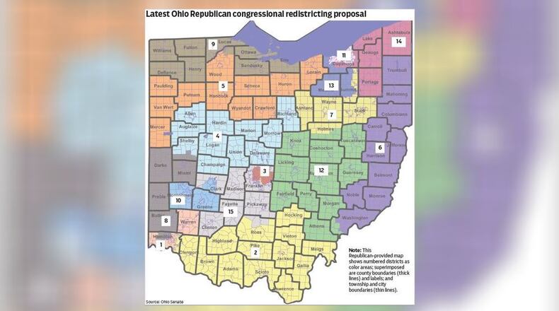
Democratic and Republican leaders in both the House and Senate put forth rival maps. After 8 p.m. Monday, House and Senate Republicans put forth identical maps as revisions to their earlier bills.
Cupp released a statement along with the revised map, saying he expects it to move through the House Government Oversight Committee on Wednesday and be up for a floor vote on Thursday.
People associated with Wright-Patterson Air Force Base, the state’s largest single-site employer with more than 30,000 workers, need to have a single regional advocate in Congress, said state Sen. Niraj Antani, R-Miamisburg. The new U.S. House District 10, which keeps together Montgomery and Greene counties, provides that; the original Senate Republican map would have cut incumbent U.S. Rep. Mike Turner, R-Dayton, off from Wright-Patt.
“This map is good for the military men and women at Wright-Patt, it is good for the Dayton region, and I look forward to supporting it,” Antani said.
State legislators have until Nov. 30 to approve new congressional districts. Republicans, who control both Ohio General Assembly chambers, can pass a map by simple majority without any Democratic support. But it would have to be redone in four years. To last for a decade, a map would have to get a three-fifths overall majority and support from one-third of Democrats.
Both sides talked frequently about their hopes to pass a 10-year map, but Democrats said they were cut out of meaningful negotiations.
State Sen. Rob McColley, R-Napoleon, sponsored the original bill and introduced the substitute as well. Calling it “the most competitive map offered by any caucus to date,” he said it splits only 12 of Ohio’s 88 counties, with only two of them split twice: Hamilton and Cuyahoga.
That’s fewer than Democratic maps, and the fewest splits in more than 50 years, McColley said.
“This map has six seats that lean Republican, seven seats that are competitive, and two seats that lean Democrat,” he said. All the districts deemed competitive have a partisan difference no greater than 8%, McColley said.
Ohio’s 16 current House seats are occupied by 12 Republicans and four Democrats. Due to results of the 2020 census, Ohio must lose one House seat.
State Sen. Tina Maharath, D-Canal Winchester, asked in committee when work began on the substitute map. She first saw it Monday night through media reports, she said.
McColley said the revised map was worked out by Cupp and Senate President Matt Huffman, R-Lima, over the preceding week.
“I believe the maps were finalized at some point Friday,” he said, adding that it was “conceptually” agreed to Friday and finalized Monday.
State Sen. Vernon Sykes, D-Akron, asked if Republicans were open to further negotiation. He had only just seen the maps and wasn’t privy to any of the discussion, he said.
McColley deferred that question to Cupp and Huffman.
Mia Lewis, associate director of Common Cause Ohio, denounced at a Senate committee hearing Tuesday morning the map’s late release, and — echoing many earlier comments — and said the map systematically split urban and minority communities to dilute their voting clout.
Jen Miller, executive director for the League of Women Voters Ohio, said the final version was even less competitive than earlier proposals. It contains “all kinds of weird squiggly splits” to maintain or increase Republicans’ advantage, she said.
Several speakers at the committee meeting expressed frustration, saying they believed many hours of public testimony had been ignored.
Before the full Senate, Republicans insisted they listened to public input and said many changes sought in testimony were incorporated. They said the map keeps seven of Ohio’s eight most populous cities whole. The exception is Columbus, which is too large to fit within one House district. Each district must have about 786,630 residents.
Sen. Cecil Thomas, D-Cincinnati, said that while the city of Cincinnati is kept whole, Hamilton County will be “hacked into three districts.”
“The supposed competitive district leans Republican by more than three points,” despite years of electoral results showing Hamilton is predominantly Democratic, he said.
Thomas said it’s obvious such splits were made to reduce the voting power of minorities.
“The line between District 1 and District 8 cuts right through the middle of the Black population,” he said. “That wasn’t accidental. That was intentional.”
About the Author

